|
|
Antenna Structure Registration 1000021 |
 |
Registration Info | Registration Number: 1000021 |
| File Number: A0121318 |
| FAA Study: 96-AWP-1085-OE |
| Status: Cancelled |
| FAA EMI: N |
| NEPA: N |
Structure Info
| Structure Type: TOWER |
| Structure Coordinates: 37-53-34.0 N 121-54-3.0 W (NAD 83) |
| Structure Coordinates: 37-53-34.3 N 121-53-59.2 W (Converted to NAD 27) |
| Structure Address: Mount Diablo North Peak |
| Structure City: San Francisco, CA |
| Structure County: Contra Costa County |
| Painting & Lighting Info |
FAA Chapters: NONE |
| Elevation Info |
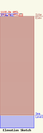
Site Elevation: 1081.4 meters (3548 ft) |
| Height of Structure: 27.4 meters (90 feet) |
| Overall Height Above Ground: 27.4 meters (90 feet) |
| Overall Height Above Mean Sea Level: 1108.8 meters (3638 feet) |
| Owner Info | LA RUE, KNOX
2171 RALPH AVE
STOCKTON, CA 95206
(209) 462-6059
|
