|
|
Antenna Structure Registration 1049714 |
 |
Registration Info | Registration Number: 1049714 |
| File Number: A1052668 |
| FAA Study: 2016-ACE-3470-OE |
| FAA Issue Date: 11/02/2016 |
| Status: Constructed |
| Date Constructed: 08/01/1994 |
| NEPA: N |
Structure Info
| Structure Type: GTOWER |
| Structure Coordinates: 40-11-5.5 N 96-58-28.2 W (NAD 83) |
| Structure Coordinates: 40-11-05.5 N 96-58-27.1 W (Converted to NAD 27) |
| Structure Address: 1/2 Mi S Of Hwy 136 |
| Structure City: Harbine, NE |
| Structure County: Jefferson County |
| Painting & Lighting Info |
FAA Circular #: 70/7460-1H |
FAA Chapters: 3, 4, 5, 13 |
Remarks: OM&L to remain the same as prior study = PAINT/RED LIGHTS |
Remarks: PRIOR STUDY 1992-ACE-578-OE |
Remarks: OM&L to remain the same as prior study = PAINT/RED LIGHTS |
Remarks: PRIOR STUDY 1992-ACE-578-OE |
| Elevation Info |
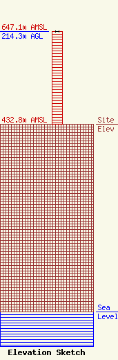
Site Elevation: 432.8 meters (1420 ft) |
| Height of Structure: 214.3 meters (703 feet) |
| Overall Height Above Ground: 214.3 meters (703 feet) |
| Overall Height Above Mean Sea Level: 647.1 meters (2123 feet) |
| Owner Info | Flood Communications of Beatrice, LLC
214 N. 7th St.
Norfolk, NE 68701
(402) 371-0100
mflood@newschannelnebraska.com |
| Contact Info | Fletcher, Heald & Hildreth, PLC
1300 N 17th Street
Arlington, VA 22209
Matthew McCormick
(703) 812-0425
mccormick@fhhlaw.com |
