|
|
Antenna Structure Registration 1048174 |
 |
Registration Info | Registration Number: 1048174 |
| File Number: A1235163 |
| FAA Study: 97-ASW-1266-OE |
| FAA Issue Date: 06/04/1997 |
| Status: Constructed |
| Date Constructed: 01/28/1997 |
| FAA EMI: N |
| NEPA: N |
Structure Info
| Structure Type: TOWER |
| Structure Coordinates: 32-39-32.0 N 99-27-12.0 W (NAD 83) |
| Structure Coordinates: 32-39-31.6 N 99-27-10.7 W (Converted to NAD 27) |
| Structure Address: 19.7m N Of I20 On Tx Hwy 351 |
| Structure City: Albany, TX |
| Structure County: Shackelford County |
| Painting & Lighting Info |
FCC Paragraph(s): 1, 3, 4, 13, 21 |
Remarks: PREVIOUS FAA 75-ASW-0621-OE. OM&L TO REMAIN RED LIGHTS/PAINT. |
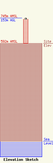
| Elevation Info |
Site Elevation: 592 meters (1942 ft) |
| Height of Structure: 147 meters (482 feet) |
| Overall Height Above Ground: 153 meters (502 feet) |
| Overall Height Above Mean Sea Level: 745 meters (2444 feet) |
| Owner Info | K2 Towers III, LLC
57 E Washington St
Chagrin Falls, OH 44022
(440) 528-0333
rlepene@k2towers.com |
| Contact Info | K2 Towers III, LLC
57 E Washington St
Chagrin Falls, OH 44022
Greg Thompson
(440) 528-0333
gthompson@k2towers.com |
