|
|
Antenna Structure Registration 1045883 |
 |
Registration Info | Registration Number: 1045883 |
| File Number: A1246534 |
| FAA Study: 2006-ACE-2600-OE |
| FAA Issue Date: 10/20/2006 |
| Status: Constructed |
| Date Constructed: 01/01/1998 |
| FAA EMI: N |
| NEPA: N |
Structure Info
| Structure Type: TOWER |
| Structure Coordinates: 41-41-23.0 N 92-21-31.6 W (NAD 83) |
| Structure Coordinates: 41-41-23.0 N 92-21-30.9 W (Converted to NAD 27) |
| Structure Address: Sw Cor Of I80 And Sr 21 |
| Structure City: Victor, IA |
| Structure County: Poweshiek County |
| Painting & Lighting Info |
FAA Circular #: 70/7460-1J |
FAA Chapters: 3, 4, 5, 13 |
Remarks: PRIOR STUDY 2006-ACE-1382-OE |
Remarks: OM&L to remain the same as prior study = PAINT/RED LIGHTS |
Remarks: PRIOR STUDY 2006-ACE-1382-OE |
Remarks: OM&L to remain the same as prior study = PAINT/RED LIGHTS |
| Elevation Info |
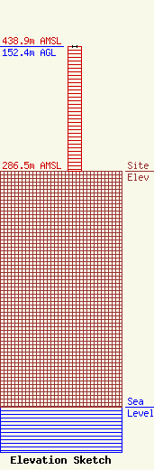
Site Elevation: 286.5 meters (940 ft) |
| Height of Structure: 152 meters (499 feet) |
| Overall Height Above Ground: 152.4 meters (500 feet) |
| Overall Height Above Mean Sea Level: 438.9 meters (1440 feet) |
| Owner Info | FLORIDA PUBLIC RADIO INC
505 JOSEPHINE ST
TITUSVILLE, FL 32796
(321) 267-3000
WPIO@GATE.NET |
| Contact Info | Wilkinson Barker Knauer, LLP
1800 M Street, NW
Washington, DC 20036
Davina Sashkin
(202) 383-3428
dsashkin@wbklaw.com |
