|
|
Antenna Structure Registration 1061103 |
 |
Registration Info | Registration Number: 1061103 |
| File Number: A0857673 |
| FAA Study: 2013-ANM-1315-OE |
| FAA Issue Date: 06/14/2013 |
| Status: Constructed |
| Date Constructed: 05/09/2013 |
| FAA EMI: N |
| NEPA: N |
Structure Info
| Structure Type: GTOWER |
| Structure Coordinates: 40-36-56.0 N 103-2-4.0 W (NAD 83) |
| Structure Coordinates: 40-36-56.0 N 103-02-02.3 W (Converted to NAD 27) |
| Structure Address: 10 Mi Se |
| Structure City: Sterling, CO |
| Structure County: Logan County |
| Painting & Lighting Info |
FAA Circular #: 70/7460-1K |
FAA Chapters: 4, 6, 12 |
Remarks: PRIOR STUDY 1999-ANM-699-OE |
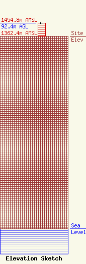
| Elevation Info |
Site Elevation: 1362.4 meters (4470 ft) |
| Height of Structure: 92.4 meters (303 feet) |
| Overall Height Above Ground: 92.4 meters (303 feet) |
| Overall Height Above Mean Sea Level: 1454.8 meters (4773 feet) |
| Owner Info | Sterling Tower, LLC
p.o. box 175
Merino, CO 80741
(970) 521-2453
KENT@KCI.NET |
| Contact Info | Sterling Tower LLC
407 Lee St.
175
Merino, CO 80741
Kent Sager
(970) 521-2453
kent@kci.net |
