|
|
Antenna Structure Registration 1063890 |
 |
Registration Info | Registration Number: 1063890 |
| File Number: A1313613 |
| FAA Study: 2024-ASW-16532-OE |
| FAA Issue Date: 02/19/2025 |
| Status: Constructed |
| Date Constructed: 02/20/1991 |
| NEPA: N |
Structure Info
| Structure Type: GTOWER |
| Structure Coordinates: 35-8-25.3 N 95-21-25.8 W (NAD 83) |
| Structure Coordinates: 35-08-24.9 N 95-21-24.9 W (Converted to NAD 27) |
| Structure Address: 1 Mile Ne Of Quinton (209205) |
| Structure City: Quinton, OK |
| Structure County: Pittsburg County |
| Painting & Lighting Info |
FAA Circular #: 70/7460-1G |
FAA Chapters: 3, 4, 5, 9 |
Remarks: PRIOR STUDY 2019-ASW-107-OE |
Remarks: OM&L to remain the same as prior study = PAINT/RED LIGHTS |
Remarks: PRIOR STUDY 2019-ASW-107-OE |
Remarks: OM&L to remain the same as prior study = PAINT/RED LIGHTS |
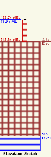
| Elevation Info |
Site Elevation: 343.8 meters (1128 ft) |
| Height of Structure: 79.2 meters (260 feet) |
| Overall Height Above Ground: 79.9 meters (262 feet) |
| Overall Height Above Mean Sea Level: 423.7 meters (1390 feet) |
| Owner Info | American Towers LLC
10 Presidential Way
Woburn, MA 01801
(781) 926-4500
faa-fcc@americantower.com |
| Contact Info | American Towers LLC
10 Presidential Way
Woburn, MA 01801
(781) 926-4500
faa-fcc@americantower.com |
