|
|
Antenna Structure Registration 1257980 |
 |
Registration Info | Registration Number: 1257980 |
| File Number: A0580457 |
| FAA Study: 2007-ASW-6456-OE |
| FAA Issue Date: 08/10/2007 |
| Status: Constructed |
| Date Constructed: 12/01/2007 |
| FAA EMI: N |
| NEPA: N |
Structure Info
| Structure Type: TOWER |
| Structure Coordinates: 35-32-53.5 N 95-58-15.0 W (NAD 83) |
| Structure Coordinates: 35-32-53.1 N 95-58-14.0 W (Converted to NAD 27) |
| Structure Address: 0.45 Miles Nw Of The Int. Of N 3960 Rd. And E 1015 Rd. In Okmulgee County, Ok |
| Structure City: Schulter, OK |
| Structure County: Okmulgee County |
| Painting & Lighting Info |
FAA Circular #: 70/7460-1K |
FAA Chapters: 4, 6, 12 |
Remarks: PRIOR STUDY 2007-ASW-752-OE |
Remarks: Removed expiration date from determination. Scenario 1./jjs/case#635066 |
| Elevation Info |
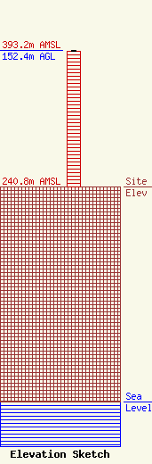
Site Elevation: 240.8 meters (790 ft) |
| Height of Structure: 151.5 meters (497 feet) |
| Overall Height Above Ground: 152.4 meters (500 feet) |
| Overall Height Above Mean Sea Level: 393.2 meters (1290 feet) |
| Owner Info | South Central Oklahoma Christian Broadcasting, Inc.
1343
Ada, OK 74820
(580) 456-7488
email@thegospelstation.com |
