|
|
Antenna Structure Registration 1223563 |
 |
Registration Info | Registration Number: 1223563 |
| File Number: A0591496 |
| FAA Study: 2006-ANM-450-OE |
| FAA Issue Date: 03/09/2006 |
| Status: Constructed |
| Date Constructed: 04/17/2008 |
| FAA EMI: N |
| NEPA: N |
Structure Info
| Structure Type: TOWER |
| Structure Coordinates: 43-34-49.2 N 121-34-17.5 W (NAD 83) |
| Structure Coordinates: 43-34-49.8 N 121-34-13.4 W (Converted to NAD 27) |
| Structure Address: 149653 Hwy 97 |
| Structure City: Gilchrist, OR |
| Structure County: Klamath County |
| Painting & Lighting Info |
FAA Circular #: 70/7460-1K |
FAA Chapters: 4, 8, 12 |
Remarks: PRIOR STUDY 2005-ANM-605-OE |
Remarks: Removed expiration date from determination. Scenario 1./jjs/case#635066 |
Remarks: OM&L to remain the same as prior study = A MED-DUAL SYSTEM |
Remarks: PRIOR STUDY 2005-ANM-605-OE |
Remarks: Removed expiration date from determination. Scenario 1./jjs/case#635066 |
| Elevation Info |
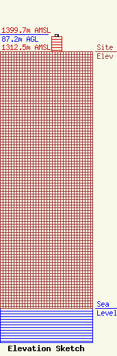
Site Elevation: 1312.5 meters (4306 ft) |
| Height of Structure: 76.2 meters (250 feet) |
| Overall Height Above Ground: 87.2 meters (286 feet) |
| Overall Height Above Mean Sea Level: 1399.7 meters (4592 feet) |
| Owner Info | Subcarrier Communications, Inc.
139 White Oak Lane
Old Bridge, NJ 08857
John Paleski
(732) 607-2828
|
| Info |
