|
|
Antenna Structure Registration 1231674 |
 |
Registration Info | Registration Number: 1231674 |
| File Number: A1258310 |
| FAA Study: 98-ANM-0765-OE |
| FAA Issue Date: 01/04/2002 |
| Status: Constructed |
| Date Constructed: 06/04/2002 |
| FAA EMI: N |
| NEPA: N |
Structure Info
| Structure Type: TOWER |
| Structure Coordinates: 46-58-30.6 N 123-8-21.0 W (NAD 83) |
| Structure Coordinates: 46-58-31.3 N 123-08-16.5 W (Converted to NAD 27) |
| Structure Address: Top Of Capitol Peak |
| Structure City: Littlerock, WA |
| Structure County: Thurston County |
| Painting & Lighting Info |
FAA Circular #: 70/7460-1J |
FAA Chapters: 3, 4, 5, 13 |
Remarks: EXTENSION GRANTED 3-28-2000 |
Remarks: Removed expiration date from determination. Scenario 1./jjs/case#635066 |
Remarks: EXTENSION GRANTED 3-28-2000 |
Remarks: Removed expiration date from determination. Scenario 1./jjs/case#635066 |
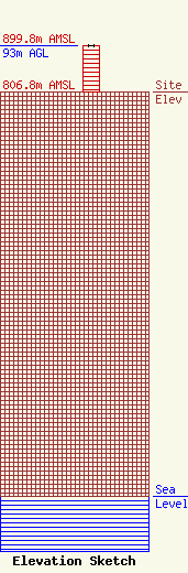
| Elevation Info |
Site Elevation: 806.8 meters (2647 ft) |
| Height of Structure: 91.4 meters (300 feet) |
| Overall Height Above Ground: 93 meters (305 feet) |
| Overall Height Above Mean Sea Level: 899.8 meters (2952 feet) |
| Owner Info | Weyerhaeuser NR Company
510 N Evans St
98520
Aberdeen, WA 98520
(360) 537-8266
WTLRadioLicensing@weyerhaeuser.com |
| Contact Info | Weyerhaeuser NR Company
510 N Evans St
98520
Aberdeen, WA 98520
Eric Deckard
(360) 537-8266
WTLRadioLicensing@weyerhaeuser.com |
