|
|
Antenna Structure Registration 1048547 |
 |
Registration Info | Registration Number: 1048547 |
| File Number: A0057095 |
| FAA Study: 94-ANM-0811-OE |
| Status: Granted |
| NEPA: N |
Structure Info
| Structure Type: TOWER |
| Structure Coordinates: 42-15-28.0 N 123-39-36.0 W (NAD 83) |
| Structure Coordinates: 42-15-28.6 N 123-39-31.8 W (Converted to NAD 27) |
| Structure Address: Eight Dollar Mountain, 10.6 Km On Bearing Of 355 Degrees From Cave Junction, Or |
| Structure City: Cave Junction, OR |
| Structure County: Josephine County |
| Painting & Lighting Info |
FAA Chapters: NONE |
| Elevation Info |
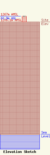
Site Elevation: 1206.1 meters (3957 ft) |
| Height of Structure: 60.9 meters (200 feet) |
| Overall Height Above Ground: 60.9 meters (200 feet) |
| Overall Height Above Mean Sea Level: 1267 meters (4157 feet) |
| Owner Info | OPUS BROADCASTING SYSTEMS, INC. DBA = OPUS BROADCASTING SYSTEMS, INC.
1257 N. RIVERSIDE AVE., SUITE #10
MEDFORD, OR 97501
(541) 772-0322
|
