|
|
Antenna Structure Registration 1014014 |
 |
Registration Info | Registration Number: 1014014 |
| File Number: A1314719 |
| FAA Study: 77-ASO-2233-OE |
| FAA Issue Date: 01/24/1978 |
| Status: Granted |
| Date Constructed: 09/01/1978 |
| FAA EMI: N |
| NEPA: N |
Structure Info
|
| Structure Coordinates: 33-42-35.0 N 79-48-30.0 W (NAD 83) |
| Structure Coordinates: 33-42-34.4 N 79-48-30.7 W (Converted to NAD 27) |
| Structure Address: 1709 Eastland Ave. |
| Structure City: Kingstree, SC |
| Structure County: Williamsburg County |
| Painting & Lighting Info |
FCC Paragraph(s): 1, 3, 4, 13, 21 |
Remarks: RED LIGHTS/PAINT |
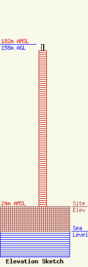
| Elevation Info |
Site Elevation: 24 meters (79 ft) |
| Height of Structure: 152 meters (499 feet) |
| Overall Height Above Ground: 158 meters (518 feet) |
| Overall Height Above Mean Sea Level: 182 meters (597 feet) |
| Owner Info | Coker Building Supply
480
Kingstree, SC 29556
(843) 382-2396
cokerbld@ftc-i.net |
| Contact Info | Coker Building Supply
480
Kingstree, SC 29556
Amy Coker Hill
(843) 687-4933
cokerbld@ftc-i.net |
