|
|
Antenna Structure Registration 1033832 |
 |
Registration Info | Registration Number: 1033832 |
| File Number: A1164333 |
| FAA Study: 2009-AEA-1425-OE |
| FAA Issue Date: 05/27/2009 |
| Status: Constructed |
| Date Constructed: 05/30/2010 |
| FAA EMI: N |
| NEPA: N |
Structure Info
|
| Structure Coordinates: 40-3-24.3 N 80-42-52.9 W (NAD 83) |
| Structure Coordinates: 40-03-24.0 N 80-42-53.6 W (Converted to NAD 27) |
| Structure Address: Old Hubbard Rd Ext |
| Structure City: Wheeling, WV |
| Structure County: Ohio County |
| Painting & Lighting Info |
FCC Paragraph(s): A1, H, 3, 11, 21, 23 |
Remarks: Continue As Is OM&L = A MED-DUAL SYSTEM |
Remarks: PRIOR STUDY 1998-AEA-1236-OE |
Remarks: Continue As Is OM&L = A MED-DUAL SYSTEM |
Remarks: PRIOR STUDY 1998-AEA-1236-OE |
| Elevation Info |
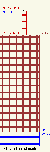
Site Elevation: 362.5 meters (1189 ft) |
| Height of Structure: 91.4 meters (300 feet) |
| Overall Height Above Ground: 96 meters (315 feet) |
| Overall Height Above Mean Sea Level: 458.5 meters (1504 feet) |
| Owner Info | Staley Wireless LP
2 - 22nd Street, Suite 100
Wheeling, WV 26003
(888) 718-0709
mark@staleywireless.com |
| Contact Info | Staley Wireless LP
2 - 22nd Street, Suite 100
Wheeling, WV 26003
Mark Staley
(888) 718-0709
mark@staleywireless.com |
