|
|
Antenna Structure Registration 1034085 |
 |
Registration Info | Registration Number: 1034085 |
| File Number: A0462711 |
| FAA Study: 86-AGL-1716-OE |
| FAA Issue Date: 03/27/1987 |
| Status: Constructed |
| Date Constructed: 02/19/1988 |
| FAA EMI: N |
| NEPA: N |
Structure Info
| Structure Type: 2TOWER |
| Structure Coordinates: 44-53-17.0 N 89-39-7.0 W (NAD 83) |
| Structure Coordinates: 44-53-17.1 N 89-39-06.6 W (Converted to NAD 27) |
| Structure Address: Twr 2 - 7700 Mosinee Tower Road |
| Structure City: Wausau, WI |
| Structure County: Marathon County |
| Painting & Lighting Info |
FCC Paragraph(s): 1, 3, 11, 21 |
Remarks: RED LIGHTS/PAINT |
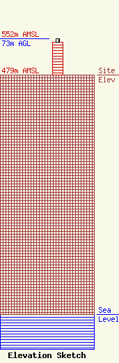
| Elevation Info |
Site Elevation: 479 meters (1572 ft) |
| Height of Structure: 67 meters (220 feet) |
| Overall Height Above Ground: 73 meters (240 feet) |
| Overall Height Above Mean Sea Level: 552 meters (1811 feet) |
| Owner Info | NORTHWAY COMMUNICATIONS INC
105 E OAK ST
WAUSAU, WI 54401
(715) 842-0841
don@northwaycom.com |
| Contact Info | NORTHWAY COMMUNICATIONS INC.
105 EAST OAK STREET
WAUSAU, WI 54401
DONALD PAGENKOPF
(715) 842-0841
don@northwaycom.com |
