|
|
Antenna Structure Registration 1000826 |
 |
Registration Info | Registration Number: 1000826 |
| File Number: A0000984 |
| Status: Constructed |
| Date Constructed: 01/01/1988 |
| NEPA: N |
Structure Info
| Structure Type: TOWER |
| Structure Coordinates: 42-5-52.0 N 86-26-15.0 W (NAD 83) |
| Structure Coordinates: 42-05-51.9 N 86-26-14.9 W (Converted to NAD 27) |
| Structure Address: 1001 Pipestone Ave |
| Structure City: Benton Harbor, MI |
| Structure County: Berrien County |
| Painting & Lighting Info |
FCC Paragraph(s): None |
| Elevation Info |
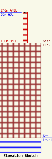
Site Elevation: 186 meters (610 ft) |
| Height of Structure: 60 meters (197 feet) |
| Overall Height Above Ground: 60 meters (197 feet) |
| Overall Height Above Mean Sea Level: 246 meters (807 feet) |
| Owner Info | T R T COMPANY
511 E 8TH ST
HOLLAND, MI 49423
(616) 396-3541
|
