|
|
Antenna Structure Registration 1026748 |
 |
Registration Info | Registration Number: 1026748 |
| File Number: A0921574 |
| FAA Study: 87-AEA-1385-OE |
| FAA Issue Date: 09/21/1987 |
| Status: Constructed |
| Date Constructed: 12/09/1987 |
| FAA EMI: N |
| NEPA: N |
Structure Info
| Structure Type: LTOWER |
| Structure Coordinates: 40-58-10.0 N 75-57-9.0 W (NAD 83) |
| Structure Coordinates: 40-58-09.7 N 75-57-10.3 W (Converted to NAD 27) |
| Structure Address: 1025 E. 9th Street |
| Structure City: Hazelton, PA |
| Structure County: Luzerne County |
| Painting & Lighting Info |
FAA Circular #: 70/7460-1G |
FAA Chapters: 3, 4, 5, 9 |
| Elevation Info |
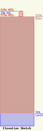
Site Elevation: 575 meters (1886 ft) |
| Height of Structure: 33 meters (108 feet) |
| Overall Height Above Ground: 33 meters (108 feet) |
| Overall Height Above Mean Sea Level: 608 meters (1995 feet) |
| Owner Info | SERVICE ELECTRIC CABLEVISION, INC.
4949 Liberty Lane, Suite 400
ALLENTOWN, PA 18106
(610) 432-2210
james.dorsa@secv.com |
| Contact Info | Service Electric Cablevision, Inc.
4949 Liberty Lane, Suite 400
Allentown, PA 18106
James Dorsa
(610) 432-2210
jim.dorsa@secv.com |
