|
|
Antenna Structure Registration 1032622 |
 |
Registration Info | Registration Number: 1032622 |
| File Number: A0038688 |
| FAA Study: 97-ASO-0772-OE |
| Status: Granted |
| NEPA: N |
Structure Info
| Structure Type: TOWER |
| Structure Coordinates: 34-13-59.0 N 85-14-2.0 W (NAD 83) |
| Structure Coordinates: 34-13-58.7 N 85-14-02.2 W (Converted to NAD 27) |
| Structure Address: 1.8km N. Of Int. Of Horseleg Creek Rd And Radio Springs Rd |
| Structure City: Rome, GA |
| Structure County: Floyd County |
| Painting & Lighting Info |
FAA Circular #: 70/7460-1J |
FAA Chapters: 4, 6, 13 |
| Elevation Info |
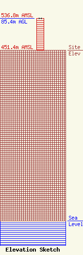
Site Elevation: 451.4 meters (1481 ft) |
| Height of Structure: 85.4 meters (280 feet) |
| Overall Height Above Ground: 85.4 meters (280 feet) |
| Overall Height Above Mean Sea Level: 536.8 meters (1761 feet) |
| Owner Info | NORFOLK - SOUTHERN
8915 SHERBROOK CT.
OWINGS, MD 20736
(301) 855-2886
TOWERS@EROLS.COM |
