|
|
Antenna Structure Registration 1292800 |
 |
Registration Info | Registration Number: 1292800 |
| File Number: A1286082 |
| FAA Study: 86-ASO-154-OE |
| FAA Issue Date: 06/17/1987 |
| Status: Constructed |
| Date Constructed: 10/21/2014 |
Structure Info
| Structure Type: GTOWER |
| Structure Coordinates: 33-6-50.0 N 83-13-8.0 W (NAD 83) |
| Structure Coordinates: 33-06-49.5 N 83-13-08.4 W (Converted to NAD 27) |
| Structure Address: 185 Ivey Weaver Rd. |
| Structure City: Milledgeville, GA |
| Structure County: Baldwin County |
| Painting & Lighting Info |
FCC Paragraph(s): 1, 3, 4, 13, 21 |
Remarks: RED LIGHTS/PAINT |
| Elevation Info |
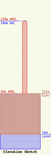
Site Elevation: 82 meters (269 ft) |
| Height of Structure: 146 meters (479 feet) |
| Overall Height Above Ground: 146 meters (479 feet) |
| Overall Height Above Mean Sea Level: 228 meters (748 feet) |
| Owner Info | Labranja Radio, LLC
4970 Cascade Road SW
Atlanta, GA 30331
(404) 735-2903
bundragelester@gmail.com |
| Contact Info | Rockwell Media Services, LLC
158 West 1600 South, Suite 200
1194
Saint George, UT 84771
Morgan Skinner
(435) 634-1400
morgan@rockwellmedia.net |
