|
|
Antenna Structure Registration 1029297 |
 |
Registration Info | Registration Number: 1029297 |
| File Number: A1149657 |
| FAA Study: 2019-AGL-19726-OE |
| FAA Issue Date: 12/12/2019 |
| Status: Granted |
| Date Constructed: 09/27/1995 |
| NEPA: N |
Structure Info
| Structure Type: LTOWER |
| Structure Coordinates: 40-19-17.0 N 87-19-9.0 W (NAD 83) |
| Structure Coordinates: 40-19-16.9 N 87-19-09.0 W (Converted to NAD 27) |
| Structure Address: 2.25 Mi N |
| Structure City: Williamsport, IN |
| Structure County: Warren County |
| Painting & Lighting Info |
FAA Circular #: 70/7460-1L |
FAA Chapters: 4, 8, 12 |
Remarks: PRIOR STUDY 1995-AGL-2938-OE |
| Elevation Info |
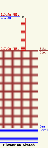
Site Elevation: 217.9 meters (715 ft) |
| Height of Structure: 92.3 meters (303 feet) |
| Overall Height Above Ground: 96 meters (315 feet) |
| Overall Height Above Mean Sea Level: 313.9 meters (1030 feet) |
| Owner Info | Cellco Partnership
5055 North Point Pkwy
Alpharetta, GA 30022
(770) 797-1070
Network.Regulatory@verizonwireless.com |
| Contact Info | Cellco Partnership
5055 North Point Pkwy
Alpharetta, GA 30022
Regulatory Manager
(770) 797-1070
Network.Regulatory@verizonwireless.com |
