|
|
Antenna Structure Registration 1060959 |
 |
Registration Info | Registration Number: 1060959 |
| File Number: A0071425 |
| FAA Study: 87-ASO-1103-OE |
| FAA Issue Date: 08/07/1987 |
| Status: Constructed |
| Date Constructed: 06/02/1987 |
| NEPA: N |
Structure Info
| Structure Type: TOWER |
| Structure Coordinates: 32-45-13.0 N 83-33-46.0 W (NAD 83) |
| Structure Coordinates: 32-45-12.5 N 83-33-46.3 W (Converted to NAD 27) |
| Structure Address: 6525 Ocmulgee East Blvd. |
| Structure City: Macon, GA |
| Structure County: Bibb County |
| Painting & Lighting Info |
FAA Circular #: 70/7460-1G |
FAA Chapters: 3, 4, 5, 9 |
| Elevation Info |
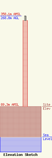
Site Elevation: 89.3 meters (293 ft) |
| Height of Structure: 255.1 meters (837 feet) |
| Overall Height Above Ground: 268.8 meters (882 feet) |
| Overall Height Above Mean Sea Level: 358.1 meters (1175 feet) |
| Owner Info | MORRIS NETWORK, INC. DBA = WMGT
6525 OCMULGEE EAST BLVD.
4328
MACON, GA 31217-9705
(912) 745-4141
CBRUCE@HOM.NET |
