|
|
Antenna Structure Registration 1211530 |
 |
Registration Info | Registration Number: 1211530 |
| File Number: A1211314 |
| FAA Study: 78-ANE-23-OE |
| FAA Issue Date: 02/06/1978 |
| Status: Constructed |
| Date Constructed: 06/10/1947 |
| FAA EMI: N |
| NEPA: N |
Structure Info
| Structure Type: TOWER |
| Structure Coordinates: 41-49-15.4 N 71-23-5.2 W (NAD 83) |
| Structure Coordinates: 41-49-15.0 N 71-23-07.0 W (Converted to NAD 27) |
| Structure Address: End Of Water Street |
| Structure City: East Providence, RI |
| Structure County: Providence County |
| Painting & Lighting Info |
FCC Paragraph(s): 1 |
Remarks: PAINT ONLY |
| Elevation Info |
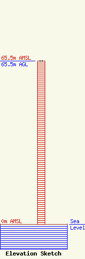
Site Elevation: 0 meters |
| Height of Structure: 65.5 meters (215 feet) |
| Overall Height Above Ground: 65.5 meters (215 feet) |
| Overall Height Above Mean Sea Level: 65.5 meters (215 feet) |
| Owner Info | Diaz Holdings, LLC
1818 Hamilton St
Allentown, PA 18104
(484) 619-9234
nadiaz4413@outlook.com |
| Contact Info | Diaz Holdings, LLC
1818 Hamilton St
Allentown, PA 18104
Nelson Diaz
(484) 619-9234
nadiaz4413@outlook.com |
