|
|
Antenna Structure Registration 1033427 |
 |
Registration Info | Registration Number: 1033427 |
| File Number: A0898638 |
| FAA Study: 71-EA-330-OE |
| FAA Issue Date: 06/21/1971 |
| Status: Constructed |
| Date Constructed: 01/01/1971 |
| FAA EMI: N |
| NEPA: N |
Structure Info
| Structure Type: TOWER |
| Structure Coordinates: 42-3-18.0 N 78-27-27.0 W (NAD 83) |
| Structure Coordinates: 42-03-17.8 N 78-27-27.9 W (Converted to NAD 27) |
| Structure Address: Approx 3 Mi Sw |
| Structure City: Olean, NY |
| Structure County: Cattaraugus County |
| Painting & Lighting Info |
FCC Paragraph(s): 1, 3, 11, 21 |
Remarks: RED LIGHTS/PAINT |
| Elevation Info |
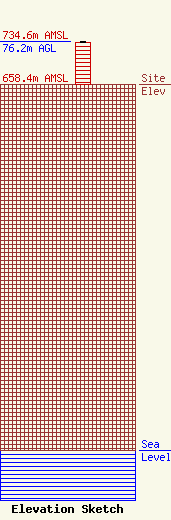
Site Elevation: 658.4 meters (2160 ft) |
| Height of Structure: 74.7 meters (245 feet) |
| Overall Height Above Ground: 76.2 meters (250 feet) |
| Overall Height Above Mean Sea Level: 734.6 meters (2410 feet) |
| Owner Info | Calvary Chapel of Russell
8160 Market Street
Russell, PA 16345
(814) 757-8744
pastorjim@ccrussell.org |
| Contact Info | Calvary Chapel of Russell
8160 Market Street
Russell, PA 16345
James Stowe
(814) 757-8744
pastorjim@ccrussell.org |
