|
|
Antenna Structure Registration 1231521 |
 |
Registration Info | Registration Number: 1231521 |
| File Number: A1288192 |
| FAA Study: 2024-AEA-5302-OE |
| FAA Issue Date: 07/08/2024 |
| Status: Granted |
| Date Constructed: 02/01/2001 |
| NEPA: N |
Structure Info
| Structure Type: LTOWER |
| Structure Coordinates: 40-46-23.6 N 76-21-16.5 W (NAD 83) |
| Structure Coordinates: 40-46-23.3 N 76-21-17.7 W (Converted to NAD 27) |
| Structure Address: Hilltop South End Of Brough Of Ashland |
| Structure City: Ashland, PA |
| Structure County: Schuylkill County |
| Painting & Lighting Info |
FAA Circular #: 70/7460-1K |
FAA Chapters: 4, 6, 12 |
Remarks: PRIOR STUDY 2001-AEA-2870-OE |
Remarks: OM&L to remain the same as prior study = 24-HR MED-STROBES |
Remarks: PRIOR STUDY 2001-AEA-2870-OE |
Remarks: OM&L to remain the same as prior study = 24-HR MED-STROBES |
| Elevation Info |
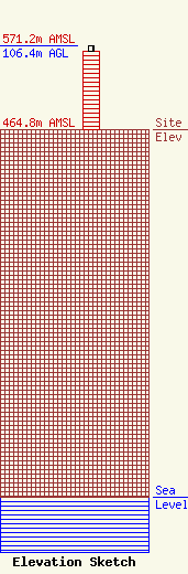
Site Elevation: 464.8 meters (1525 ft) |
| Height of Structure: 100.3 meters (329 feet) |
| Overall Height Above Ground: 106.4 meters (349 feet) |
| Overall Height Above Mean Sea Level: 571.2 meters (1874 feet) |
| Owner Info | Jordan Realty, Inc.
210 West Market Street
Pottsville, PA 17901
(570) 628-5209
rcgreen@schmobile.com |
| Contact Info | Jordan Realty, Inc.
210 West Market Street
Pottsville, PA 17901
Robert Green
(570) 628-5209
rcgreen@schmobile.com |
