|
|
Antenna Structure Registration 1000295 |
 |
Registration Info | Registration Number: 1000295 |
| File Number: A0598411 |
| FAA Study: 89-ASO-0115-OE |
| Status: Constructed |
| Date Constructed: 01/01/1989 |
| FAA EMI: N |
| NEPA: N |
Structure Info
| Structure Type: TOWER |
| Structure Coordinates: 36-0-8.0 N 83-56-41.0 W (NAD 83) |
| Structure Coordinates: 36-00-07.7 N 83-56-41.3 W (Converted to NAD 27) |
| Structure Address: 331 Sharp Ridge Memorial Dr |
| Structure City: Knoxville, TN |
| Structure County: Knox County |
| Painting & Lighting Info |
FAA Chapters: NONE |
| Elevation Info |
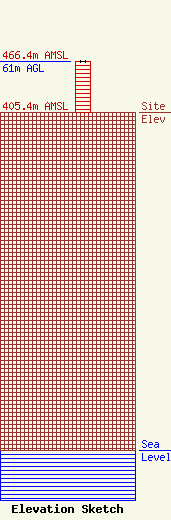
Site Elevation: 405.4 meters (1330 ft) |
| Height of Structure: 61 meters (200 feet) |
| Overall Height Above Ground: 61 meters (200 feet) |
| Overall Height Above Mean Sea Level: 466.4 meters (1530 feet) |
| Info |
