|
|
Antenna Structure Registration 1022111 |
 |
Registration Info | Registration Number: 1022111 |
| File Number: A0026400 |
| FAA Study: 98-ASW-4678-OE |
| Status: Constructed |
| Date Constructed: 01/01/1976 |
| NEPA: N |
Structure Info
| Structure Type: TOWER |
| Structure Coordinates: 30-12-43.0 N 93-35-18.0 W (NAD 83) |
| Structure Coordinates: 30-12-42.3 N 93-35-17.4 W (Converted to NAD 27) |
| Structure Address: 2 Miles N |
| Structure City: Vinton, LA |
| Structure County: Calcasieu Parish |
| Painting & Lighting Info |
FAA Circular #: 70/7460-1J |
FAA Chapters: 4, 6, 13 |
| Elevation Info |
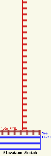
Site Elevation: 4.6 meters (15 ft) |
| Height of Structure: 134 meters (440 feet) |
| Overall Height Above Ground: 134 meters (440 feet) |
| Overall Height Above Mean Sea Level: 138.6 meters (455 feet) |
| Owner Info | UCAR PIPELINE CORPORATION
P. O. BOX 186
PORT LAVACA, TX 77979
(512) 553-3174
|
