|
|
Antenna Structure Registration 1227428 |
 |
Registration Info | Registration Number: 1227428 |
| File Number: A1253498 |
| FAA Study: 2022-ANE-5833-OE |
| FAA Issue Date: 04/19/2023 |
| Status: Constructed |
| Date Constructed: 07/04/2002 |
| NEPA: N |
Structure Info
| Structure Type: GTOWER |
| Structure Coordinates: 42-28-31.4 N 73-16-5.0 W (NAD 83) |
| Structure Coordinates: 42-28-31.1 N 73-16-06.6 W (Converted to NAD 27) |
| Structure Address: 39 1/2 Lakewood Drive (ma10019-a) |
| Structure City: Pittsfield, MA |
| Structure County: Berkshire County |
| Painting & Lighting Info |
FAA Circular #: 70/7460-1K |
FAA Chapters: 4, 8, 12 |
Remarks: PRIOR STUDY 2007-ANE-1390-OE |
Remarks: OM&L to remain the same as prior study = A MED-DUAL SYSTEM |
Remarks: PRIOR STUDY 2007-ANE-1390-OE |
Remarks: OM&L to remain the same as prior study = A MED-DUAL SYSTEM |
| Elevation Info |
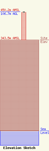
Site Elevation: 343.5 meters (1127 ft) |
| Height of Structure: 105.2 meters (345 feet) |
| Overall Height Above Ground: 106.7 meters (350 feet) |
| Overall Height Above Mean Sea Level: 450.2 meters (1477 feet) |
| Owner Info | SBA Towers II LLC
8051 Congress Avenue
Boca Raton, FL 33487
(561) 995-7670
ERoach@sbasite.com |
| Contact Info | SBA Towers II LLC
8051 Congress Avenue
Boca Raton, FL 33487
(561) 995-7670
ERoach@sbasite.com |
