|
|
Antenna Structure Registration 1065130 |
 |
Registration Info | Registration Number: 1065130 |
| File Number: A0789432 |
| FAA Study: 2010-AEA-2788-OE |
| FAA Issue Date: 07/28/2010 |
| Status: Constructed |
| Date Constructed: 01/01/1998 |
| FAA EMI: N |
| NEPA: N |
Structure Info
| Structure Type: TOWER |
| Structure Coordinates: 39-37-36.2 N 77-42-37.8 W (NAD 83) |
| Structure Coordinates: 39-37-35.9 N 77-42-38.8 W (Converted to NAD 27) |
| Structure Address: 880 Commonwealth Ave |
| Structure City: Hagerstown, MD |
| Structure County: Washington County |
| Painting & Lighting Info |
FAA Circular #: 70/7460-1K |
FAA Chapters: 3, 4, 5, 12 |
Remarks: PRIOR STUDY 2010-AEA-1436-OE |
| Elevation Info |
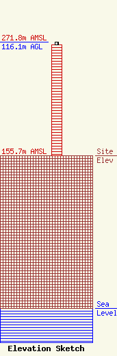
Site Elevation: 155.7 meters (511 ft) |
| Height of Structure: 113.2 meters (371 feet) |
| Overall Height Above Ground: 116.1 meters (381 feet) |
| Overall Height Above Mean Sea Level: 271.8 meters (892 feet) |
| Owner Info | Manning Broadcasting, Inc.
880 Commonwealth Avenue
Hagerstown, MD 21740
(301) 733-4500
fredmanning@comcast.net |
| Contact Info | Pillsbury Winthrop Shaw Pittman LLP
2300 N Street, NW
Washington, DC 20037
Miles Mason
(202) 663-8195
miles.mason@pillsburylaw.com |
