|
|
Antenna Structure Registration 1032934 |
 |
Registration Info | Registration Number: 1032934 |
| File Number: A0939983 |
| FAA Study: 97-AEA-2394-OE |
| FAA Issue Date: 09/13/1997 |
| Status: Constructed |
| Date Constructed: 08/01/1975 |
| NEPA: N |
Structure Info
| Structure Type: LTOWER |
| Structure Coordinates: 40-28-9.0 N 76-3-45.0 W (NAD 83) |
| Structure Coordinates: 40-28-08.7 N 76-03-46.2 W (Converted to NAD 27) |
| Structure Address: Centre - 700 Bootleg Road |
| Structure City: Bernville, PA |
| Structure County: Berks County |
| Painting & Lighting Info |
FAA Circular #: 70/7460-1J |
FAA Chapters: 4, 6, 13 |
| Elevation Info |
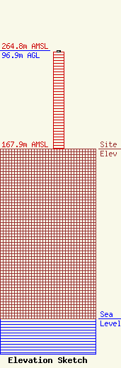
Site Elevation: 167.9 meters (551 ft) |
| Height of Structure: 96 meters (315 feet) |
| Overall Height Above Ground: 96.9 meters (318 feet) |
| Overall Height Above Mean Sea Level: 264.8 meters (869 feet) |
| Owner Info | Berks, County of
2561 Bernville Rd.
Reading, PA 19605
(610) 374-4800
Bgottschall@countyofberks.com |
| Contact Info | L.R. Kimball
4400 Deer Path Rd. Suite 105
Harrisburg, PA 17110
(717) 221-8820
Rusty.himelwright@lrkimball.com |
