|
|
Antenna Structure Registration 1027119 |
 |
Registration Info | Registration Number: 1027119 |
| File Number: A1047791 |
| Status: Constructed |
| Date Constructed: 10/01/1989 |
| FAA EMI: N |
| NEPA: N |
Structure Info
| Structure Type: TOWER |
| Structure Coordinates: 41-11-1.0 N 75-52-1.0 W (NAD 83) |
| Structure Coordinates: 41-11-00.7 N 75-52-02.3 W (Converted to NAD 27) |
| Structure Address: Penobscot Mountain Access Rd Off Sterling In Mountaintop Pa |
| Structure City: Hanover Township, PA |
| Structure County: Luzerne County |
| Painting & Lighting Info |
FCC Paragraph(s): 1, 3, 6, 15, 21 |
| Elevation Info |
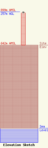
Site Elevation: 642 meters (2106 ft) |
| Height of Structure: 248 meters (814 feet) |
| Overall Height Above Ground: 257 meters (843 feet) |
| Overall Height Above Mean Sea Level: 899 meters (2949 feet) |
| Owner Info | Subcarrier Communications Inc
139 White Oak Lane
Old Bridge, NJ 08857
(732) 607-2828
subcom1@subcarrier.com |
| Contact Info | Subcarrier Communications Inc
139 White Oak Lane
Old Bridge, NJ 08857
John Paleski
(732) 607-2828
subcom1@subcarrier.com |
