|
|
Antenna Structure Registration 1003999 |
 |
Registration Info | Registration Number: 1003999 |
| File Number: A0805883 |
| FAA Study: 2012-AEA-3309-OE |
| FAA Issue Date: 07/23/2012 |
| Status: Constructed |
| Date Constructed: 07/23/2012 |
| FAA EMI: N |
| NEPA: N |
Structure Info
| Structure Type: GTOWER |
| Structure Coordinates: 42-58-25.6 N 76-11-49.5 W (NAD 83) |
| Structure Coordinates: 42-58-25.4 N 76-11-50.8 W (Converted to NAD 27) |
| Structure Address: 4139 Makyes Road (277386) |
| Structure City: Syracuse, NY |
| Structure County: Onondaga County |
| Painting & Lighting Info |
FAA Circular #: 70/7460-1H |
FAA Chapters: 4, 8, 13 |
Remarks: PRIOR STUDY 2008-AEA-2679-OE |
Remarks: OM&L to remain the same as prior study = A MED-DUAL SYSTEM |
Remarks: PRIOR STUDY 2008-AEA-2679-OE |
Remarks: OM&L to remain the same as prior study = A MED-DUAL SYSTEM |
| Elevation Info |
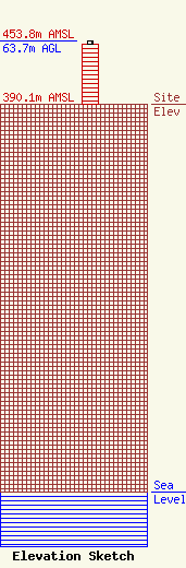
Site Elevation: 390.1 meters (1280 ft) |
| Height of Structure: 60 meters (197 feet) |
| Overall Height Above Ground: 63.7 meters (209 feet) |
| Overall Height Above Mean Sea Level: 453.8 meters (1489 feet) |
| Owner Info | American Towers LLC
10 Presidential Way
Woburn, MA 01801
(678) 564-3236
faa-faa@americantower.com |
| Contact Info | American Towers, LLC.
10 Presidential Way
Woburn, MA 01801
(678) 564-3236
faa-fcc@americantower.com |
