|
|
Antenna Structure Registration 1207081 |
 |
Registration Info | Registration Number: 1207081 |
| File Number: A1297790 |
| FAA Study: 2023-AGL-3598-OE |
| FAA Issue Date: 05/22/2023 |
| Status: Constructed |
| Date Constructed: 12/06/1999 |
| NEPA: N |
Structure Info
| Structure Type: LTOWER |
| Structure Coordinates: 41-42-51.8 N 83-30-22.2 W (NAD 83) |
| Structure Coordinates: 41-42-51.6 N 83-30-22.4 W (Converted to NAD 27) |
| Structure Address: 1706 Matzinger Rd (#22627) |
| Structure City: Toledo, OH |
| Structure County: Lucas County |
| Painting & Lighting Info |
FAA Circular #: 70/7460-1M |
FAA Chapters: 4, 8, 15 |
Remarks: PRIOR STUDY 2013-AGL-10252-OE |
| Elevation Info |
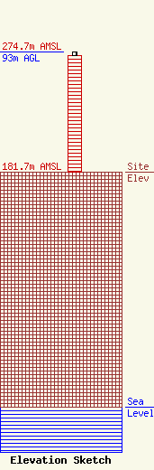
Site Elevation: 181.7 meters (596 ft) |
| Height of Structure: 90.2 meters (296 feet) |
| Overall Height Above Ground: 93 meters (305 feet) |
| Overall Height Above Mean Sea Level: 274.7 meters (901 feet) |
| Owner Info | American Towers LLC
10 Presidential Way
Woburn, MA 01801
(781) 926-4500
faa-fcc@americantower.com |
| Contact Info | American Towers LLC
10 Presidential Way
Woburn, MA 01801
(781) 926-4500
faa-fcc@americantower.com |
