|
|
Antenna Structure Registration 1038414 |
 |
Registration Info | Registration Number: 1038414 |
| File Number: A1374289 |
| FAA Study: 2011-ASO-7947-OE |
| FAA Issue Date: 01/10/2012 |
| Status: Constructed |
| Date Constructed: 02/18/1994 |
| FAA EMI: N |
| NEPA: N |
Structure Info
| Structure Type: MAST |
| Structure Coordinates: 36-2-47.5 N 86-49-46.5 W (NAD 83) |
| Structure Coordinates: 36-02-47.3 N 86-49-46.5 W (Converted to NAD 27) |
| Structure Address: 1406 Old Hickory Blvd |
| Structure City: Forrest Hills, TN |
| Structure County: Davidson County |
| Painting & Lighting Info |
FAA Chapters: NONE |
Remarks: PRIOR STUDY 2009-ASO-4143-OE |
| Elevation Info |
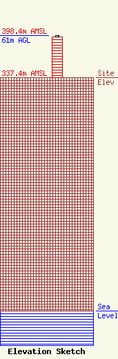
Site Elevation: 337.4 meters (1107 ft) |
| Height of Structure: 58.8 meters (193 feet) |
| Overall Height Above Ground: 61 meters (200 feet) |
| Overall Height Above Mean Sea Level: 398.4 meters (1307 feet) |
| Owner Info | Crown Castle GT Company, LLC
2000 Corporate Drive
Canonsburg, PA 15317
(724) 416-2400
Regulatory.Department@crowncastle.com |
| Contact Info | Crown Castle
2000 Corporate Drive
Canonsburg, PA 15317
Tom Anderson
(724) 743-6330
Tom.Anderson@crowncastle.com |
