|
|
Antenna Structure Registration 1020676 |
 |
Registration Info | Registration Number: 1020676 |
| File Number: A1344523 |
| FAA Study: 2010-ASO-566-OE |
| FAA Issue Date: 02/23/2010 |
| Status: Constructed |
| Date Constructed: 02/26/2010 |
| FAA EMI: N |
| NEPA: N |
Structure Info
| Structure Type: TOWER |
| Structure Coordinates: 33-30-23.0 N 81-57-43.0 W (NAD 83) |
| Structure Coordinates: 33-30-22.5 N 81-57-43.6 W (Converted to NAD 27) |
| Structure Address: 1305 Georgia Ave |
| Structure City: North Augusta, SC |
| Structure County: Aiken County |
| Painting & Lighting Info |
FAA Chapters: NONE |
Remarks: PRIOR STUDY 1996-ASO-2070-OE |
| Elevation Info |
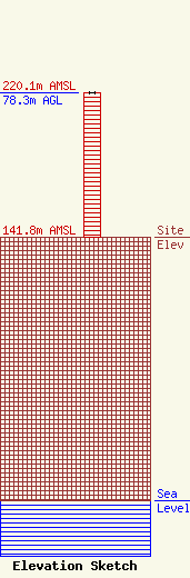
Site Elevation: 141.8 meters (465 ft) |
| Height of Structure: 78.3 meters (257 feet) |
| Overall Height Above Ground: 78.3 meters (257 feet) |
| Overall Height Above Mean Sea Level: 220.1 meters (722 feet) |
| Owner Info | Vertical Bridge CC FM, LLC
22 W Atlantic Avenue
Delray Beach, FL 33444
(561) 406-4015
fcc-faa@verticalbridge.com |
| Contact Info | Vertical Bridge CC FM, LLC
22 W Atlantic Avenue
Delray Beach, FL 33444
Richard Hickey
(561) 406-4015
fcc-faa@verticalbridge.com |
