|
|
Antenna Structure Registration 1057289 |
 |
Registration Info | Registration Number: 1057289 |
| File Number: A1065195 |
| FAA Study: 2011-ANE-1894-OE |
| FAA Issue Date: 12/01/2011 |
| Status: Constructed |
| Date Constructed: 01/01/1985 |
| FAA EMI: N |
| NEPA: N |
Structure Info
| Structure Type: 2TA1 |
| Structure Coordinates: 41-6-54.6 N 73-26-3.4 W (NAD 83) |
| Structure Coordinates: 41-06-54.3 N 73-26-05.0 W (Converted to NAD 27) |
| Structure Address: Twr 1 - 6 Shirley St |
| Structure City: Norwalk, CT |
| Structure County: Fairfield County |
| Painting & Lighting Info |
FAA Chapters: NONE |
Remarks: PRIOR STUDY 2011-ANE-1877-OE |
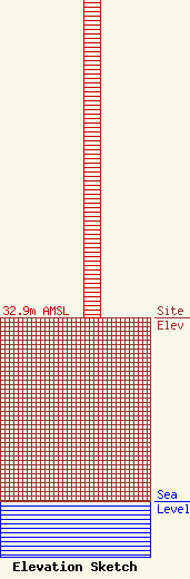
| Elevation Info |
Site Elevation: 32.9 meters (108 ft) |
| Height of Structure: 62.2 meters (204 feet) |
| Overall Height Above Ground: 63 meters (207 feet) |
| Overall Height Above Mean Sea Level: 95.9 meters (315 feet) |
| Owner Info | Sacred Heart University, Incorporated
5151 Park Avenue
Fairfield, CT 06825
(203) 365-6604
lombardi@wshu.org |
| Info |
