|
|
Antenna Structure Registration 1013596 |
 |
Registration Info | Registration Number: 1013596 |
| File Number: A0016279 |
| FAA Study: 82-AGL-1268-OE |
| FAA Issue Date: 06/22/1983 |
| Status: Constructed |
| Date Constructed: 06/01/1983 |
| NEPA: N |
Structure Info
| Structure Type: TOWER |
| Structure Coordinates: 39-16-24.0 N 84-31-37.0 W (NAD 83) |
| Structure Coordinates: 39-16-23.8 N 84-31-37.2 W (Converted to NAD 27) |
| Structure Address: 1211 W Sharon Rd |
| Structure City: Cincinnati, OH |
| Structure County: Hamilton County |
| Painting & Lighting Info |
FAA Circular #: 70/7460-1D |
FAA Chapters: 4, 7, 9 |
Remarks: DUAL HIGH INTENSITY |
| Elevation Info |
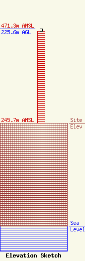
Site Elevation: 245.7 meters (806 ft) |
| Height of Structure: 219.5 meters (720 feet) |
| Overall Height Above Ground: 225.6 meters (740 feet) |
| Overall Height Above Mean Sea Level: 471.3 meters (1546 feet) |
| Owner Info | COMBINED TECHNOLOGIES INCORPORATED
1211 W SHARON RD
CINCINNATI, OH 45240
(513) 742-5555
|
