|
|
Antenna Structure Registration 1035419 |
 |
Registration Info | Registration Number: 1035419 |
| File Number: A1248090 |
| Status: Constructed |
| Date Constructed: 01/01/1983 |
| FAA EMI: N |
| NEPA: N |
Structure Info
| Structure Type: TOWER |
| Structure Coordinates: 42-38-14.0 N 73-10-6.0 W (NAD 83) |
| Structure Coordinates: 42-38-13.7 N 73-10-07.6 W (Converted to NAD 27) |
| Structure Address: Mount Greylock |
| Structure City: Williamstown, MA |
| Structure County: Berkshire County |
| Painting & Lighting Info |
FCC Paragraph(s): 1, 3, 11, 21 |
| Elevation Info |
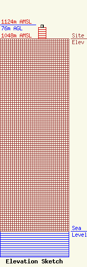
Site Elevation: 1048 meters (3438 ft) |
| Height of Structure: 61 meters (200 feet) |
| Overall Height Above Ground: 76 meters (249 feet) |
| Overall Height Above Mean Sea Level: 1124 meters (3688 feet) |
| Owner Info | WAMC
318 Central Avenue
Albany, NY 12206
(518) 465-5233
mail@wamc.org |
| Contact Info | Gray Miller Persh LLP
2233 Wisconsin Ave., NW
Washington, DC 20007
Barry Persh
(202) 776-2458
bpersh@graymillerpersh.com |
