|
|
Antenna Structure Registration 1218712 |
 |
Registration Info | Registration Number: 1218712 |
| File Number: A0654165 |
| FAA Study: 00-ASO-4929-OE |
| FAA Issue Date: 10/11/2000 |
| Status: Constructed |
| Date Constructed: 02/04/2002 |
| FAA EMI: N |
| NEPA: N |
Structure Info
| Structure Type: TOWER |
| Structure Coordinates: 34-11-57.3 N 89-49-9.3 W (NAD 83) |
| Structure Coordinates: 34-11-56.9 N 89-49-09.0 W (Converted to NAD 27) |
| Structure Address: Snider Road |
| Structure City: Pope, MS |
| Structure County: Panola County |
| Painting & Lighting Info |
FAA Circular #: 70/7460-1K |
FAA Chapters: 4, 7, 12 |
Remarks: Removed expiration and final dates from determination. Scenario 2./jjs/case#635066 |
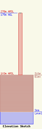
| Elevation Info |
Site Elevation: 103 meters (338 ft) |
| Height of Structure: 175 meters (574 feet) |
| Overall Height Above Ground: 175 meters (574 feet) |
| Overall Height Above Mean Sea Level: 278 meters (912 feet) |
| Owner Info | AMERICAN FAMILY ASSOCIATION
P.O. DRAWER 2440
TUPELO, MS 38803
(662) 844-8888
JES@AFA.NET |
| Info |
