|
|
Antenna Structure Registration 1207609 |
 |
Registration Info | Registration Number: 1207609 |
| File Number: A1343000 |
| FAA Study: 2024-AGL-1440-OE |
| FAA Issue Date: 02/23/2024 |
| Status: Constructed |
| Date Constructed: 11/19/2000 |
| NEPA: N |
Structure Info
| Structure Type: GTOWER |
| Structure Coordinates: 37-51-20.4 N 89-8-22.2 W (NAD 83) |
| Structure Coordinates: 37-51-20.2 N 89-08-21.9 W (Converted to NAD 27) |
| Structure Address: State Route 149 |
| Structure City: Bush, IL |
| Structure County: Williamson County |
| Painting & Lighting Info |
FAA Circular #: 70/7460-1J |
FAA Chapters: 4, 6, 13 |
Remarks: OM&L to remain the same as prior study = 24-HR MED-STROBES |
Remarks: PRIOR STUDY 1999-AGL-5442-OE |
Remarks: OM&L to remain the same as prior study = 24-HR MED-STROBES |
Remarks: PRIOR STUDY 1999-AGL-5442-OE |
| Elevation Info |
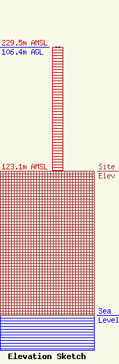
Site Elevation: 123.1 meters (404 ft) |
| Height of Structure: 106.4 meters (349 feet) |
| Overall Height Above Ground: 106.4 meters (349 feet) |
| Overall Height Above Mean Sea Level: 229.5 meters (753 feet) |
| Owner Info | VB-S1 Assets, LLC
22 W Atlantic Avenue
Delray Beach, FL 33444
(561) 406-4015
fcc-faa@verticalbridge.com |
| Contact Info | VB-S1 Assets, LLC
22 W Atlantic Avenue
Delray Beach, FL 33444
Richard Hickey
(561) 406-4015
fcc-faa@verticalbridge.com |
