|
|
Antenna Structure Registration 1038794 |
 |
Registration Info | Registration Number: 1038794 |
| File Number: A1376185 |
| FAA Study: 2025-ASO-20588-OE |
| FAA Issue Date: 01/26/2026 |
| Status: Constructed |
| Date Constructed: 05/25/1995 |
| NEPA: N |
Structure Info
| Structure Type: GTOWER |
| Structure Coordinates: 33-57-30.4 N 86-13-0.6 W (NAD 83) |
| Structure Coordinates: 33-57-30.0 N 86-13-00.7 W (Converted to NAD 27) |
| Structure Address: 499 Towers Rd (300220) |
| Structure City: Steele, AL |
| Structure County: St. Clair County |
| Painting & Lighting Info |
FAA Circular #: 70/7460-1L |
FAA Chapters: 4, 8, 12 |
Remarks: OM&L to remain the same as prior study = A MED-DUAL SYSTEM |
Remarks: PRIOR STUDY 2019-ASO-8444-OE |
Remarks: OM&L to remain the same as prior study = A MED-DUAL SYSTEM |
Remarks: PRIOR STUDY 2019-ASO-8444-OE |
| Elevation Info |
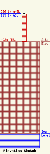
Site Elevation: 403 meters (1322 ft) |
| Height of Structure: 120.4 meters (395 feet) |
| Overall Height Above Ground: 123.1 meters (404 feet) |
| Overall Height Above Mean Sea Level: 526.1 meters (1726 feet) |
| Owner Info | American Towers LLC
10 Presidential Way
Woburn, MA 01801
(781) 926-4500
faa-fcc@americantower.com |
| Contact Info | |

