|
|
Antenna Structure Registration 1044797 |
 |
Registration Info | Registration Number: 1044797 |
| File Number: A0549955 |
| FAA Study: 2007-ASO-759-OE |
| FAA Issue Date: 03/21/2007 |
| Status: Constructed |
| Date Constructed: 05/17/2007 |
| FAA EMI: N |
| NEPA: N |
Structure Info
| Structure Type: TOWER |
| Structure Coordinates: 37-1-13.4 N 84-23-42.6 W (NAD 83) |
| Structure Coordinates: 37-01-13.1 N 84-23-42.8 W (Converted to NAD 27) |
| Structure Address: 642 Old Whitney Road |
| Structure City: Somerset, KY |
| Structure County: Pulaski County |
| Painting & Lighting Info |
FAA Circular #: 70/7460-1J |
FAA Chapters: 3, 4, 5, 13 |
Remarks: PRIOR STUDY 1998-ASO-1379-OE |
Remarks: OM&L to remain the same as prior study = PAINT/RED LIGHTS |
| Elevation Info |
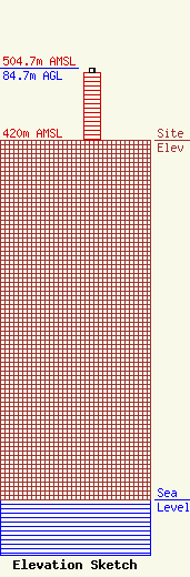
Site Elevation: 420 meters (1378 ft) |
| Height of Structure: 79.9 meters (262 feet) |
| Overall Height Above Ground: 84.7 meters (278 feet) |
| Overall Height Above Mean Sea Level: 504.7 meters (1656 feet) |
| Owner Info | KENTUCKY, COMMONWEALTH OF DBA = KY EMERGENCY WARNING SYSTEM KEWS
100 Minuteman Pky Building 101
Frankfort, KY 40601
(502) 564-5397
william.hays@ky.gov |
