|
|
Antenna Structure Registration 1260693 |
 |
Registration Info | Registration Number: 1260693 |
| File Number: A0597891 |
| FAA Study: 2007-ASO-5349-OE |
| FAA Issue Date: 10/31/2007 |
| Status: Constructed |
| Date Constructed: 06/24/2008 |
| FAA EMI: N |
| NEPA: N |
Structure Info
| Structure Type: TOWER |
| Structure Coordinates: 30-42-22.7 N 84-37-39.1 W (NAD 83) |
| Structure Coordinates: 30-42-22.0 N 84-37-39.4 W (Converted to NAD 27) |
| Structure Address: On Georgia Hiway 302. 4.09 Miles South Of Faceville, Ga. |
| Structure City: Quincy, FL |
| Structure County: Decatur County |
| Painting & Lighting Info |
FAA Circular #: 70/7460-1K |
FAA Chapters: 3, 4, 5, 12 |
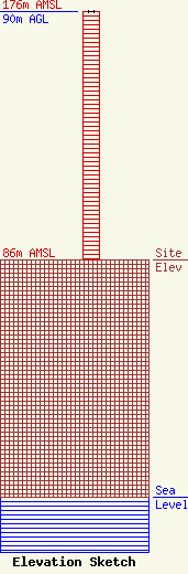
| Elevation Info |
Site Elevation: 86 meters (282 ft) |
| Height of Structure: 90 meters (295 feet) |
| Overall Height Above Ground: 90 meters (295 feet) |
| Overall Height Above Mean Sea Level: 176 meters (577 feet) |
| Owner Info | Faith Radio Network
181000
Tallahassee, FL 32318
Scott Begle
(850) 201-1070
|
| Contact Info | EME Communications
293 JC Saunders Road
Moultrie, GA 31768
Clyde Scott
(229) 890-2506
cscott@emecom.com |
