|
|
Antenna Structure Registration 1029541 |
 |
Registration Info | Registration Number: 1029541 |
| File Number: A0563188 |
| Status: Constructed |
| Date Constructed: 08/25/1989 |
| FAA EMI: N |
| NEPA: N |
Structure Info
| Structure Type: TOWER |
| Structure Coordinates: 40-17-50.0 N 86-54-5.0 W (NAD 83) |
| Structure Coordinates: 40-17-49.9 N 86-54-05.0 W (Converted to NAD 27) |
| Structure Address: 457 Meters South Of 800 South Road And 183 Meters East Of U.s. Route 231 |
| Structure City: Lafayette, IN |
| Structure County: Tippecanoe County |
| Painting & Lighting Info |
FCC Paragraph(s): 1, 3, 4, 13, 21 |
| Elevation Info |
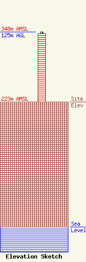
Site Elevation: 223 meters (732 ft) |
| Height of Structure: 122 meters (400 feet) |
| Overall Height Above Ground: 125 meters (410 feet) |
| Overall Height Above Mean Sea Level: 348 meters (1142 feet) |
| Owner Info | PURDUE UNIVERSITY
712 Third Street
WEST LAFAYETTE, IN 47907-2005
(765) 494-5920
mamogridge@purdue.edu |
