|
|
Antenna Structure Registration 1041107 |
 |
Registration Info | Registration Number: 1041107 |
| File Number: A1366619 |
| FAA Study: 2016-AEA-463-OE |
| FAA Issue Date: 02/11/2016 |
| Status: Constructed |
| Date Constructed: 03/02/1998 |
| NEPA: N |
Structure Info
| Structure Type: GTOWER |
| Structure Coordinates: 42-18-21.8 N 73-29-27.1 W (NAD 83) |
| Structure Coordinates: 42-18-21.5 N 73-29-28.7 W (Converted to NAD 27) |
| Structure Address: W Hill Rd |
| Structure City: Austerlitz, NY |
| Structure County: Columbia County |
| Painting & Lighting Info |
FAA Circular #: 70/7460-1K |
FAA Chapters: 4, 6, 12 |
Remarks: OM&L to remain the same as prior study = 24-HR MED-STROBES |
Remarks: PRIOR STUDY 2015-AEA-384-OE |
Remarks: OM&L to remain the same as prior study = 24-HR MED-STROBES |
Remarks: PRIOR STUDY 2015-AEA-384-OE |
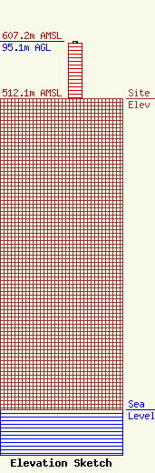
| Elevation Info |
Site Elevation: 512.1 meters (1680 ft) |
| Height of Structure: 91.4 meters (300 feet) |
| Overall Height Above Ground: 95.1 meters (312 feet) |
| Overall Height Above Mean Sea Level: 607.2 meters (1992 feet) |
| Owner Info | Pinnacle Towers LLC
2000 Corporate Drive
Canonsburg, PA 15317
(724) 416-2400
Regulatory.Department@crowncastle.com |
| Contact Info | Crown Castle
2000 Corporate Drive
Canonsburg, PA 15317
Tom Anderson
(724) 743-6330
Tom.Anderson@crowncastle.com |
