|
|
Antenna Structure Registration 1271018 |
 |
Registration Info | Registration Number: 1271018 |
| File Number: A1244582 |
| FAA Study: 2009-ASO-3547-OE |
| FAA Issue Date: 06/15/2009 |
| Status: Constructed |
| Date Constructed: 06/16/2009 |
| FAA EMI: N |
| NEPA: N |
Structure Info
| Structure Type: TOWER |
| Structure Coordinates: 29-26-8.9 N 81-9-20.3 W (NAD 83) |
| Structure Coordinates: 29-26-08.0 N 81-09-21.1 W (Converted to NAD 27) |
| Structure Address: N Of Osprey Lane; 354 Ft From Intersection Of Sr 5a (old Kings Rd) And Osprey Ln |
| Structure City: Flagler Beach, FL |
| Structure County: Flagler County |
| Painting & Lighting Info |
FAA Chapters: NONE |
Remarks: PRIOR STUDY 2009-ASO-2302-OE |
| Elevation Info |
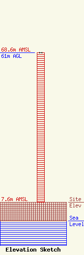
Site Elevation: 7.6 meters (25 ft) |
| Height of Structure: 61 meters (200 feet) |
| Overall Height Above Ground: 61 meters (200 feet) |
| Overall Height Above Mean Sea Level: 68.6 meters (225 feet) |
| Owner Info | Central Florida Educational Foundation, Inc.
1065 Rainer Drive
Altamonte Springs, FL 32714
(407) 869-8000
jhoge@zradio.org |
| Contact Info | Wilkinson Barker Knauer, LLP
1800 M Street, NW
Washington, DC 20036
Davina Sashkin
(202) 383-3428
dsashkin@wbklaw.com |
