|
|
Antenna Structure Registration 1065286 |
 |
Registration Info | Registration Number: 1065286 |
| File Number: A0367378 |
| FAA Study: 99-ASO-1142-OE |
| FAA Issue Date: 04/05/1999 |
| Status: Constructed |
| Date Constructed: 07/05/1999 |
| FAA EMI: N |
| NEPA: N |
Structure Info
| Structure Type: TOWER |
| Structure Coordinates: 33-18-49.0 N 83-0-5.0 W (NAD 83) |
| Structure Coordinates: 33-18-48.5 N 83-00-05.5 W (Converted to NAD 27) |
| Structure Address: Nw |
| Structure City: Sparta, GA |
| Structure County: Hancock County |
| Painting & Lighting Info |
FAA Circular #: 70/7460-1J |
FAA Chapters: 3, 4, 5, 13 |
| Elevation Info |
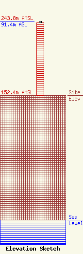
Site Elevation: 152.4 meters (500 ft) |
| Height of Structure: 89.9 meters (295 feet) |
| Overall Height Above Ground: 91.4 meters (300 feet) |
| Overall Height Above Mean Sea Level: 243.8 meters (800 feet) |
| Owner Info | BARINOWSKI INVESTMENT CO., L. P.
2278 WORTHAM LANE
GROVETOWN, GA 30813
(706) 309-9670
CTBARINOWSKI@COMCAST.NET |
