|
|
Antenna Structure Registration 1237609 |
 |
Registration Info | Registration Number: 1237609 |
| File Number: A1195909 |
| FAA Study: 2002-AGL-5083-OE |
| FAA Issue Date: 11/18/2002 |
| Status: Constructed |
| Date Constructed: 04/20/2004 |
| NEPA: N |
Structure Info
| Structure Type: LTOWER |
| Structure Coordinates: 40-39-35.1 N 81-21-25.7 W (NAD 83) |
| Structure Coordinates: 40-39-34.9 N 81-21-26.3 W (Converted to NAD 27) |
| Structure Address: 9997a Chestnut Avenue |
| Structure City: East Sparta, OH |
| Structure County: Stark County |
| Painting & Lighting Info |
FAA Circular #: 70/7460-1K |
FAA Chapters: 4, 8, 12 |
Remarks: PRIOR STUDY 2001-AGL-2506-OE |
| Elevation Info |
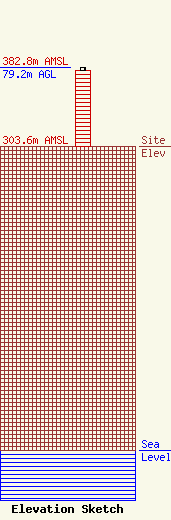
Site Elevation: 303.6 meters (996 ft) |
| Height of Structure: 76.2 meters (250 feet) |
| Overall Height Above Ground: 79.2 meters (260 feet) |
| Overall Height Above Mean Sea Level: 382.8 meters (1256 feet) |
| Owner Info | CCATT LLC
2000 Corporate Drive
Canonsburg, PA 15317
(724) 416-2000
Regulatory.Department@Crowncastle.com |
| Contact Info | Crown Castle
2000 Corporate Drive
Canonsburg, PA 15317
Don Snyder
(724) 416-2470
Don.Snyder@crowncastle.com |
