|
|
Antenna Structure Registration 1278941 |
 |
Registration Info | Registration Number: 1278941 |
| File Number: A1281214 |
| FAA Study: 2011-ASO-2562-OE |
| FAA Issue Date: 05/10/2011 |
| Status: Constructed |
| Date Constructed: 08/19/2011 |
| FAA EMI: N |
| NEPA: N |
Structure Info
| Structure Type: TOWER |
| Structure Coordinates: 33-12-30.3 N 85-59-31.2 W (NAD 83) |
| Structure Coordinates: 33-12-29.9 N 85-59-31.3 W (Converted to NAD 27) |
| Structure Address: 1750 Ft. Nnw Of Intersection Of Al Hwy 148 And Brian Rd, Clay Co Alabama |
| Structure City: Millerville, AL |
| Structure County: Clay County |
| Painting & Lighting Info |
FAA Circular #: 70/7460-1K |
FAA Chapters: 4, 6, 12 |
| Elevation Info |
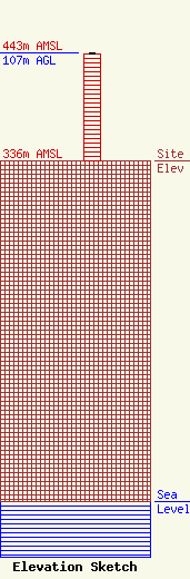
Site Elevation: 336 meters (1102 ft) |
| Height of Structure: 106 meters (348 feet) |
| Overall Height Above Ground: 107 meters (351 feet) |
| Overall Height Above Mean Sea Level: 443 meters (1453 feet) |
| Owner Info | Radioland IV LLC
205 Primrose Path
Sylacauga, AL 35150
(202) 384-9551
lperryman@radioalabama.net |
| Contact Info | Radioland IV LLC
205 Primrose Path
Sylacauga, AL 35150
Frank Perryman
(202) 384-9551
lperryman@radioalabama.net |
