|
|
Antenna Structure Registration 1256438 |
 |
Registration Info | Registration Number: 1256438 |
| File Number: A0654203 |
| FAA Study: 2006-ASO-6952-OE |
| FAA Issue Date: 12/11/2006 |
| Status: Constructed |
| Date Constructed: 05/05/2008 |
| FAA EMI: N |
| NEPA: N |
Structure Info
| Structure Type: TOWER |
| Structure Coordinates: 34-38-52.8 N 77-37-27.2 W (NAD 83) |
| Structure Coordinates: 34-38-52.2 N 77-37-28.3 W (Converted to NAD 27) |
| Structure Address: 2096 Haws Run Road |
| Structure City: Maple Hill, NC |
| Structure County: Onslow County |
| Painting & Lighting Info |
FAA Circular #: 70/7460-1K |
FAA Chapters: 4, 8, 12 |
Remarks: PRIOR STUDY 2006-ASO-3657-OE |
Remarks: Removed expiration date from determination. Scenario 1./jjs/case#635066 |
Remarks: PRIOR STUDY 2006-ASO-3657-OE |
Remarks: Removed expiration date from determination. Scenario 1./jjs/case#635066 |
| Elevation Info |
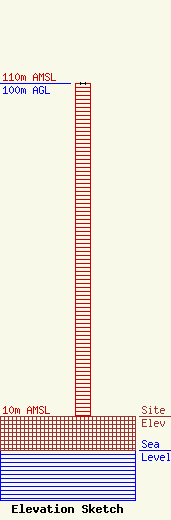
Site Elevation: 10 meters (33 ft) |
| Height of Structure: 100 meters (328 feet) |
| Overall Height Above Ground: 100 meters (328 feet) |
| Overall Height Above Mean Sea Level: 110 meters (361 feet) |
| Owner Info | AMERICAN FAMILY ASSOCIATION
P.O. DRAWER 2440
TUPELO, MS 38803
(662) 844-8888
JES@AFA.NET |
| Info |
