|
|
Antenna Structure Registration 1048741 |
 |
Registration Info | Registration Number: 1048741 |
| File Number: A0842438 |
| FAA Study: 97-AGL-2337-OE |
| Status: Constructed |
| Date Constructed: 01/01/1992 |
| FAA EMI: N |
| NEPA: N |
Structure Info
| Structure Type: TOWER |
| Structure Coordinates: 42-9-13.0 N 84-32-57.0 W (NAD 83) |
| Structure Coordinates: 42-09-12.9 N 84-32-57.2 W (Converted to NAD 27) |
| Structure Address: 1.6 Mi W |
| Structure City: Horton, MI |
| Structure County: Jackson County |
| Painting & Lighting Info |
FAA Circular #: 70/7460-1J |
FAA Chapters: 3, 4, 5, 13 |
| Elevation Info |
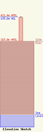
Site Elevation: 315.8 meters (1036 ft) |
| Height of Structure: 104.7 meters (344 feet) |
| Overall Height Above Ground: 105.6 meters (346 feet) |
| Overall Height Above Mean Sea Level: 421.4 meters (1383 feet) |
| Owner Info | SPRING ARBOR UNIVERSITY
106 E MAIN ST
SPRING ARBOR, MI 49283
(517) 750-1200
KAITLYN@ARBOR.EDU |
| Contact Info | SPRING ARBOR UNIVERSITY
106 E MAIN STREET
SPRING ARBOR, MI 49283
(517) 750-6540
KAITLYN@ARBOR.EDU |
