|
|
Antenna Structure Registration 1281936 |
 |
Registration Info | Registration Number: 1281936 |
| File Number: A0810257 |
| FAA Study: 2011-AGL-3973-OE |
| FAA Issue Date: 07/23/2011 |
| Status: Constructed |
| Date Constructed: 12/20/2012 |
| FAA EMI: N |
| NEPA: N |
Structure Info
| Structure Type: TOWER |
| Structure Coordinates: 45-30-31.5 N 85-2-11.0 W (NAD 83) |
| Structure Coordinates: 45-30-31.5 N 85-02-10.8 W (Converted to NAD 27) |
| Structure Address: 2931 S Beacon Hill Lane |
| Structure City: Friendship Township, MI |
| Structure County: Emmet County |
| Painting & Lighting Info |
FAA Circular #: 70/7460-1K |
FAA Chapters: 4, 8, 12 |
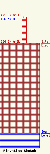
| Elevation Info |
Site Elevation: 364.8 meters (1197 ft) |
| Height of Structure: 106.5 meters (349 feet) |
| Overall Height Above Ground: 106.5 meters (349 feet) |
| Overall Height Above Mean Sea Level: 471.3 meters (1546 feet) |
| Owner Info | CCE Central Dispatch Authority
1694 S. US 131 Hwy
Petoskey, MI 49740
(231) 439-3300
bbradley@cce911.com |
| Contact Info | Tele-Rad Inc.
511 East 8th Street
Holland, MI 49423
Mark Roddy
(616) 396-3541
mark_roddy@tele-rad.com |
