|
|
Antenna Structure Registration 1055876 |
 |
Registration Info | Registration Number: 1055876 |
| File Number: A1184330 |
| FAA Study: 2015-AEA-6529-OE |
| FAA Issue Date: 02/02/2016 |
| Status: Constructed |
| Date Constructed: 10/08/1998 |
| NEPA: N |
Structure Info
| Structure Type: GTOWER |
| Structure Coordinates: 39-7-47.8 N 74-47-16.1 W (NAD 83) |
| Structure Coordinates: 39-07-47.4 N 74-47-17.5 W (Converted to NAD 27) |
| Structure Address: Rt. 9, 609 Meters Sw |
| Structure City: Swainton, NJ |
| Structure County: Cape May County |
| Painting & Lighting Info |
FAA Circular #: 70/7460-1L |
FAA Chapters: 4, 8, 12 |
Remarks: PRIOR STUDY 1998-AEA-2109-OE |
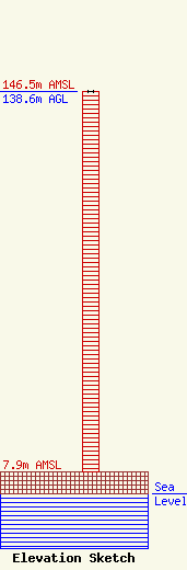
| Elevation Info |
Site Elevation: 7.9 meters (26 ft) |
| Height of Structure: 138.6 meters (455 feet) |
| Overall Height Above Ground: 138.6 meters (455 feet) |
| Overall Height Above Mean Sea Level: 146.5 meters (481 feet) |
| Owner Info | CTI Towers Assets III, LLC
5000 CentreGreen Way
Cary, NC 27513
(919) 893-2841
mbertolino@ctitowers.com |
| Contact Info | CTI Towers Assets III, LLC
5000 CentreGreen Way
Cary, NC 27513
Matthew Bertolino
(919) 893-2841
mbertolino@ctitowers.com |
